On Monday, 1st February your parish council had a presentation by a developer about a proposal to apply for planning permission for 36 affordable houses for rent and shared ownership on parcel of land on Fen Road, Milton. This meeting was attended by various villagers and, in the absence of a report from the parish council (we have asked), we are relying on their notes for this article.
The land in question is the first field on the left down Fen Road which has the woods and lake of Milton Hall, now a public open space as part of the North Lodge Park development, on the far side of it. There are houses along most of the right side of Fen Road at this point and it’s also right on the edge of the flood plain (which runs along the 5m contour).
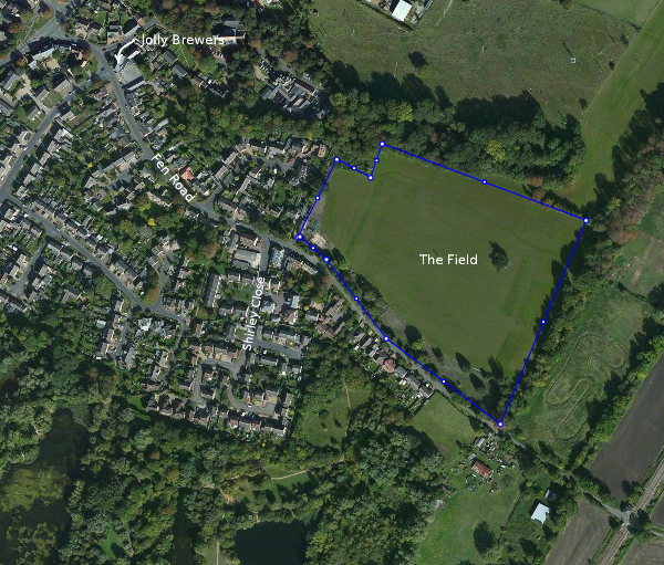
The Wilson Family Trust, who own the field, are selling 2.5 acres to the company at a price well below the market value and the company propose to build 36 homes for rented and shared ownership on that land.
All of this field is currently Green Belt and, in addition, the current planning guidance for the district says that Milton is not a village listed for large scale developments and that only small developments of no more than eight dwellings should be permitted.
The concern the villager has is that this proposed development is a trojan horse to get the field out of Green Belt as it leaves the remaining 37.4 acres of the field then open to being granted planning permission for profitable housing development.
To give you some idea of what that might mean the average housing density in the UK for new homes is now 16 per acre so even if we assume a lower density of say 10 per acre we would be talking about an additional 374 houses on the site plus 36 in the first phase giving a total of 410 homes, so that would increase the size of the village by about 20% with all that this implies for things like the impact on Milton Primary School or traffic getting out of the village in the morning.
Apparently the developer is in early discussions with the Local Planning Officer at SCDC and it will be approximately two months before any drawings are available.
Imagery © Getmapping plc © 2016 GeoEye © 2016 Intermap Earthstar Geographics SIO Earthstar Geographics SIO © 22016 Microsoft Corporation.

